 |
Inventorying, Mapping and Monitoring of Mangroves towards Sustainable Management of West Coast, India
|
 |
Prakash N. Mesta1, Bharath Setturu1,3, Subash Chandran M. D.1, Rajan K.S3, T.V. Ramachandra1,2*
1Energy & Wetlends Research Group, Center for Ecological Sciences [CES], Indian Institute of Science,
2Center for Sustainable Technologies (astra), Indian Institute of Science,
3International Institute of Information Technology-Hyderabad [IIIT-H], India.
*Corresponding author:
Energy & Wetlands Research Group,
Centre for Ecological Sciences
Indian Institute of Science,
Bangalore – 560 012, INDIA, E-mail: cestvr@ces.iisc.ac.in, energy@ces.iisc.ac.in.
Results and Discussion
Estuary-wise spatio temporal analysis provided insights regarding spatial extent and species composition of mangroves in the estuarine regions with 2 km buffer.
- Aghnashini estuary: The temporal dynamics of mangroves in the Aghnashini estuary is given in Figure 3 show an increase of vegetation from 40.79 (1989) to 44.92% (2010) due to reforestation initiatives by the forest department. Table 2 lists the land use details. Intensification of aquaculture during the early 1990’s almost wiped the mangroves and open fields were converted as aquaculture ponds. However the failure of shrimp culture in late 90’s led to natural regeneration in the region, especially in undisturbed mud plats. Subsequently, realising the importance of mangroves, village forest committees and state forest department have taken up joint initiative of reforestation with select mangrove species. Aghanashini estuary is having no dams, no notable industrial establishments along its banks and may be considered one of the most pristine ones among the other estuaries of west coast. It is a productive and biologically rich waterscape of coastal Karnataka by its ecosystem goods and services. One of the most notable economic and subsistence output of the Aghanashini estuary is the bivalves (Phylum: Mollusca). The meat of these invertebrates is used as a protein rich food by about 198,000 people along the coastal areas of Karnataka and Goa. Total annual production is 22,006 tons, valued at Rs.57.8 million per annum [39]. Coastal villages situated in close proximity to the estuary characterized by estuarine fishing, and saline tolerant paddy cultivation in ghajini (estuarine agriculture fields) lands.
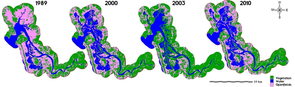 Figure 3: Aghnashini estuary (buffer)
Category
Year |
Vegetation |
Water |
Open fields |
Ha |
% |
Ha |
% |
Ha |
% |
1989 |
5675.24 |
40.79 |
2643.53 |
19 |
5595.85 |
40.22 |
2000 |
5483.63 |
39.41 |
2622.25 |
18.85 |
5808.73 |
41.75 |
2003 |
5435.51 |
39.06 |
3988.78 |
28.67 |
4490.32 |
32.27 |
2010 |
6250.39 |
44.92 |
3148 |
22.62 |
4516.21 |
32.46 |
Total area |
13914.61 |
Table 2: Spatio temporal dynamics of Aghnashini estuary (buffer).
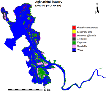
The species wise mangrove distribution is given in Figure 4. Table 3 lists the species, which shows the region is dominated by Rhizophora mucronata (1.45%) followed by Sonneratia alba (0.65%), Avicennia officinalis (0.05%). Other mangrove associated vegetation (Derris trifoliate, Cyperus malaccensis, Erythrina indica, Ficus racemosa, etc.) and coconut plantations cover about 16.45%. The availability open fields (4.85%) and mud flats (7.46%) highlight the opportunity to diversify the effort for effective management. A wide variety and assortments of fish, molluscs, crabs and prawns inhabit here, which are harvested and exported. Mangroves of Aghanashini provides a good roosting place for many species of birds, which find rich food supply in the estuary.
Figure 4. Aghnashini estuary.
Category |
Ha |
% |
Rhizophora mucronata |
74.27 |
1.42 |
Sonneratia alba |
33.72 |
0.65 |
Avicennia officinalis |
5.40 |
0.11 |
Vegetation |
857.46 |
16.37 |
Water |
3615.19 |
69.05 |
Open fields |
259.13 |
4.94 |
Mud plane |
390.83 |
7.46 |
Total area |
5236.00 |
Table 3: Species wise distribution of Aghnashini estuary.
Category
Year |
Vegetation |
Water |
Open fields |
Ha |
% |
Ha |
% |
Ha |
% |
1989 |
2280.83 |
48.77 |
715.26 |
15.29 |
1680.46 |
35.93 |
2000 |
2389.58 |
51.1 |
723.12 |
15.46 |
1563.85 |
33.44 |
2003 |
2348.34 |
50.22 |
783.66 |
16.76 |
1544.54 |
33.02 |
2010 |
2413.09 |
51.59 |
831.24 |
17.77 |
1432.24 |
30.64 |
Total area |
4676.55 |
Table 4: Spatio temporal dynamics of Gangavali estuary (buffer).
- Gangavali estuary: Figure 5 and Table 4 provide the spatial extent of land uses in Gangavali estuarine region during 1989 to 2010. The vegetation cover has increased from 48.77(1989) to 51.59% (2010) with the decline of open fields. The region contains natural growth of mangrove forests with less monoculture plantations. Owing to the tropical monsoonal climate, there is intense weathering of the hinterland, and transportation of weathered materials to the coastal environment is causing tiny sand bars. Gangavali estuary is the common breeding place for native species of penaeid prawns viz., Penaeus indicus, P. merguiensis, P. monodon and Metapenaeus dobsoni, which are providing major lively hood for the local fishermen.
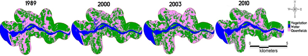
Figure5. Gangavali estuary (buffer
Species wise distribution (Figure 6 and Table 5) shows that the region consists of Rhizophora mucronata (3.010 Ha), Avicennia officinalis (2.088 Ha), Sonneratia alba (1.903 Ha). Avicenna and Sonneratia speciesgrows naturally here.Realizing the importance of mangroves, agrarians have started planting on the embankments, which protects their farmlands with the entangled roots against breaches. The river mouth has good patch dominated by Sonneratia alba. Though mangrove habitats are few, all along the edge of the river linear strip is found. Some small good patches occur at Bilihonge and Agragone villages.
Category |
Ha |
% |
Rhizophora mucronata |
3.010 |
0.46 |
Sonneratia alba |
1.903 |
0.29 |
Avicennia officinalis |
2.088 |
0.32 |
Vegetation |
36.465 |
5.58 |
Water |
500.146 |
76.6 |
Open fields |
102.622 |
15.72 |
Plantation |
6.693 |
1.03 |
Total area |
652.927 |
Table 5: Species wise distribution of Gangavali estuary.
Category
Year |
Vegetation |
Water |
Open fields |
Ha |
% |
Ha |
% |
Ha |
% |
1989 |
11111.37 |
59.7 |
2237.26 |
12.02 |
5263.12 |
28.28 |
2000 |
11049.27 |
59.37 |
2264.91 |
12.17 |
5297.56 |
28.46 |
2003 |
11076.47 |
59.51 |
2046.44 |
11 |
5488.85 |
29.49 |
2010 |
11258.78 |
60.49 |
2497.86 |
13.42 |
4855.12 |
26.09 |
Total area |
18611.75 |
Table 6: Spatio temporal dynamics of Sharavathi estuary (buffer).
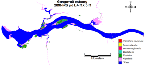
Figure 6. Gangavali estuary.
- Sharavathi estuary: Figure 7 depicts the Sharavathi estuary dynamics during 1989 to 2010.The Sharavathi River has a catchment area of 3600 sq. km. The spatio temporal dynamics as listed in Table 6 indicate the decline open fields from 28.28% to 26.09% due to enhanced agricultural activities. Non-mangroves plantations have increased in this region, evident from the conversion of open fields for coconut or other cash crop cultivations. Increase in vegetation cover from 59.7% to 60.49% is due to the plantation activities. The continuous discharge of freshwater with the construction of dams and reservoirs has changed flora and faunal dynamics in this estuary.
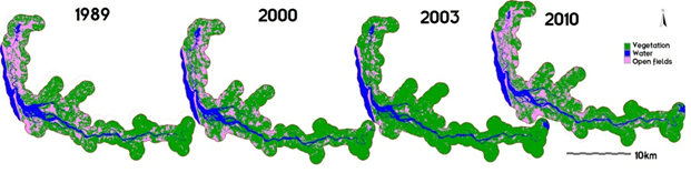
Figure 7. Sharavathi estuary (buffer).
The mangroves species distribution (figure 8) shows that this region is dominated by natural growth of Sonneratia caseolaris followed by other mangrove species like Sonneratia alba, Kandelia candel (Table 7). All species present in the region other than Sonneratia caseolaris are due to the extensive reforestation activities. The presence of moderate salinity favorable species is due to lowered salinity levels in the estuary due to the continuous flow of fresh water from the reservoir. The mangroves associated with higher salinity, such as Rhizophora spp., Avicennia marina, Sonneratia alba etc. have vanished almost totally in the lower part of estuary. Plantations other than mangroves constitute 20.53 % of the estuarine region. The Sonneratia caseolaris also grows well around the river, islands and contributes to some extent the firewood needs of the locals. The region is mainly facing a threat due to the large scale anthropogenic activities involving conversion of land for cash crops and coconut plantations. This necessitates constant vigil through regular monitoring to minimize the impacts of human induced disturbances.
Table 6à
alin= 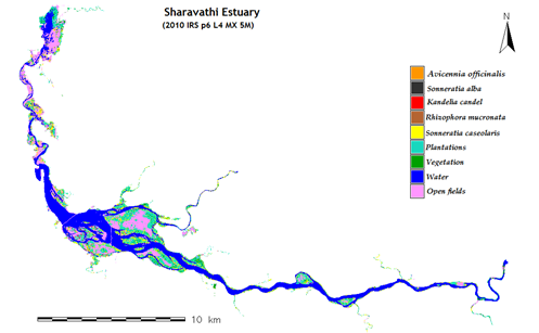 Figure 8. Sharavathi estuary
Category |
Ha |
% |
Avicennia officinalis |
10.70 |
0.31 |
Sonneratia alba |
23.00 |
0.67 |
Kandelia candel |
6.81 |
0.20 |
Rhizophora mucronata |
5.41 |
0.16 |
Sonneratia caseolaris |
81.96 |
2.40 |
Plantations |
219.65 |
6.44 |
Vegetation |
515.21 |
15.08 |
Water |
1334.90 |
39.08 |
Open fields |
1218.12 |
35.66 |
Total area |
3415.75 |
Table 7: Species wise distribution of Sharavathi estuary
- Venkatapura estuary: Venkatapura estuary is the smallest among all other estuaries in the district and a submerged bar developed due to confluence sedimentation that modify the wave pattern from west. The spatio temporal changes (Figure 9, table 8)) show the increase in the vegetation cover from 28.2 (1989) to 33.95% (2010) and decrease in the open fields. Coastal erosion is posing serious challenges due to syncronisation of flash flood in the river and strong wave activities during south west monsoon. The loss of native vegetation along the estuary is the principal reason for erosion. Due to the heavy human impact from the densely populated places like Bhatkal and Shirali as well as due to the smallness of the estuary, this region lacks significant mangrove cover.
-
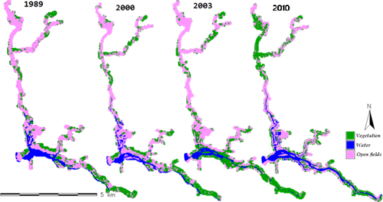
Figure 9. Venkatapura estuary (buffer).
Category
Year |
Vegetation |
Water |
Open fields |
Ha |
% |
Ha |
% |
Ha |
% |
1989 |
226.17 |
28.2 |
87.84 |
10.95 |
488.07 |
60.85 |
2000 |
243.54 |
30.36 |
84.87 |
10.58 |
473.67 |
59.06 |
2003 |
269.36 |
33.58 |
55.98 |
6.98 |
476.74 |
59.44 |
2010 |
272.33 |
33.95 |
125.36 |
15.63 |
404.39 |
50.42 |
Total area |
802.08 |
Table 8: Spatio temporal dynamics of Venkatapura estuary (buffer).
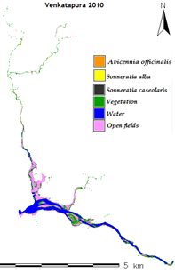
The species wise distribution map shows Sonneratia alba is the most dominant species among all (figure 10, Table 9)). Parallel to the coast, approximately at 2 m depths and at the confluence of the river mouth of the Venkatapur, concentric submerged bar is developed. The availability of 34.38% open fields shows that there are ample chances for reforestation of mangrove species. This estuary has good oyster deposits.
Category |
Ha |
% |
Avicennia officinalis |
9.88 |
4.53 |
Sonneratia alba |
5.61 |
2.57 |
Sonneratia caseolaris |
0.710 |
0.33 |
Vegetation |
56.292 |
25.82 |
Water |
70.572 |
32.37 |
Open fields |
74.947 |
34.38 |
Total |
218.009 |
Table 9: Species wise distribution of Venkatapura estuary.
Figure 10. Venkatapura estuary
Accuracy assessment is done through the computation of overall (OA), user’s (UA) and producer’s (PA) accuracies and Kappa coefficient. Training sites and transects data ensures the independence of the reference data for species mapping. Table 10 (a, b) provides the accuracy details of the study. Accuracy assessment for species wise mapping also shows greater overall accuracy and Kappa statistic. The integration of ground based field monitoring with the remote sensing data provided species level spatial distribution of mangroves. Training sites of exclusive species referred to mangrove tree species that restricted to the mangrove habitat were selected for the most common species encountered in the mangrove regions. Other species which did not form enough mono specific patches for training site selection are considered as other vegetation types. The improvement can be achieved in future by incorporating new high resolution remote sensing data for further analysis. Rate of expansion, indicates the mangrove’s ability to occupy new habitats. However degradation of mangrove habitats due to anthropogenic activities has contributed the decline in some pockets. The available open fields clearly illustrate the opportunity for effective management activities. Planting of Avicennia marina, Avicennia officinalis saplings of high salt tolerates (>25 ppt (parts-per trillion)) are suggested in the seaward end of estuaries where the freshwater discharge is low. Mangrove plant species of Rhizophora apiculata, Kandelia candel, Acanthus ilicifolius species are appropriate to be planted in seaward areas of estuaries and lagoons in the wet zone of moderate salinity tolerance (15- 25 ppt). Mangrove plant species of low salinity tolerance (< 15 ppt) Sonneratia caseolaris, Sonneratia alba, Excoecaria agallocha plants are suitable to be planted in the upper reaches of estuaries with high freshwater input (wet zone). The plantation of Avicennia marina & Avicennia officinalis are prompted in Aghnashini, Ganagavali estuaries due to their excellence in source of honey production. Apiculture has to be promoted in mangrove areas, which assists the dual purpose of increasing area under mangroves and to increase honey production.
Year |
Overall Accuracy |
Kappa |
1989 |
83.39 |
0.81 |
2000 |
84.85 |
0.80 |
2003 |
88.26 |
0.82 |
2010 |
91.21 |
0.89 |
Table 10(a): Accuracy assessment from 1989 to 2010.
Category |
Producer's Accuracy |
User's Accuracy |
Overall Accuracy |
Kappa |
Avicennia officinalis |
88.53 |
96.13 |
90.89 |
0.89 |
Sonneratia alba |
98.09 |
80.05 |
Kandelia candel |
94.58 |
82.65 |
Rhizophora mucronata |
86.50 |
93.84 |
Sonneratia caseolaris |
96.65 |
89.52 |
Table 10(b): Species wise accuracy assessment.
Citation : Mesta PN, Setturu B, Subash Chandran MD, Rajan KS, Ramachandra TV (2014) Inventorying, Mapping and Monitoring of Mangroves
towards Sustainable Management of West Coast, India. J Geophys Remote Sensing 3: 130. doi:10.4172/2169-0049.1000130.
|
|
|